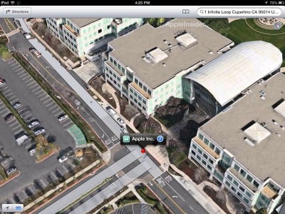
Saptamana trecuta compania Apple a anuntat lansarea oficiala a unei noi aplicatii Maps in iOS 6, iar impreuna cu ea a prezentat sistemul de harti pe care il vom utliza in viitor. Una dintre cele mai importante functii ale noii aplicatii Maps este FlyOver, un sistem 3D care ne permite sa vizualizam imagini foto-realiste a anumitor zone de pe glob. Pentru a obtine imaginile atat de clare Apple a utilizat avioane si elicoptere care au survolat orasele si au fotografiat anumite zone ale lor, acele imagini fiind procesate in laborator si incluse in acest sistem. Problema este ca Apple si Google folosesc tehnologii disponibile pana in prezent doar armatei si obtin o rezolutie foarte buna pentru aceste harti, astfel incat in aplicatii vom putea vedea la rezolutie buna chiar si oamenii care umbla pe strazile oraselor sau care se afla in curtea propriei case. Desigur ca Google StreetView oferea asa ceva, insa prin noile module 3D vom putea vedea locatiile din diverse unghiuri, inclusiv de deasupra si nu doar de la nivelul strazii.
Barbequing or sunbathing in your backyard shouldn’t be a public event. People should be free from the worry of some high-tech peeping Tom technology violating one’s privacy when in your own home. High resolution 3D mapping may have some very useful and practical applications, but the technology that is reported to be used by these companies brings a level of precision that has never before been utilized for public purposes. It raises important privacy questions and individuals have a right to know when their homes and communities are being mapped – and whether highly detailed images of them and their homes will wind up published online. By using powerful cameras that can see through your windows and display details of sensitive security sites, Apple and Google will have access to private and sensitive images. It’s imperative that these companies disclose their plans for protecting privacy of both individuals and sensitive infrastructure, their publication intentions, and their plans for including public consent in the mapping process.
Tehnologiile utilizate de cele doua companii par sa il fi deranjat pe un senator american care a trimis o scrisore deschisa presedintilor ambelor companii si le cere companiilor sa puna siguranta americanilor si a SUA pe primul loc. El spune ca imaginile de inalta rezolutie nu numai ca pot afecta intimitatea americanilor, dar pot oferi teroristilor informatii detaliate in legatura cu anumite obiective militare/civile si aici are foarte mare dreptate. Practic in noile module 3D ale Maps si Google Maps utilizatorii pot vedea cu exactitate cum arata anumite cladiri sau locatii si aici ar putea exista o amenintare destul de mare, mai ales pentru tari precum SUA. Desigur ca aceste doua companii nu vor renunta la sistemele lor si va fi interesant de vazut daca statul american va interveni pentru a le forta sa nu afiseze imagini exacte ale anumitor obiective din SUA.
Dear Apple and Google,
I write today over the recent revelations that your companies are using highly sensitive photography equipment to take pictures of cities and towns across the country for your respective mapping products. These disclosures are potentially troubling, and I request that the privacy and security of Americans remain your top priority as you deploy new mapping and imaging capability.
It has been reported that some of these sensitive cameras can take pictures of objects up to four inches wide. I fear that this clarity may allow your mapping programs to take detailed pictures of people in intimate locations such as around a pool or in someone’s backyard. People on Long Island or in Buffalo have a reasonable expectation of privacy when they decide to have a barbeque on their back deck and would prefer to retain the option of deciding whether they should be photographed on their property. They should not fear that your planes will be overhead taking detailed pictures of their private events.
Detailed photographs could also provide criminals and terrorists with detailed views of sensitive utilities. On current online maps, many power lines, power sub stations, and reservoir access points are visible only at low resolutions. However, if highly detailed images become available, criminals could create more complete schematic maps of the power and water grids in the United States. With the vast amount of infrastructure across the country, it would be impossible to secure every location.
Therefore, I request that your mapping programs include three separate privacy and security provisions:
1) Provide notification to communities as to when you plan to conduct mapping
2) Automatically blur photos of individuals who are captured, and give property owners the right to opt-out of having the company map their homes
3) Put protocols in place with law enforcement and local municipalities to ensure that sensitive infrastructure details are blurred from published maps
I hope that you would be willing to work with my office on this very important issue and ensure the security and privacy of all Americans.


